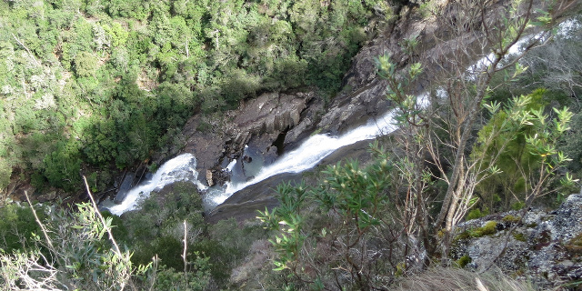
There are many places titled “Lost Falls” in the world. The ones in Tasmania are quite easy to find, flowing off Wingys Tier on the east coast. They are also quite accessible, being an easy drive from most parts of the state followed by a very short walk to the lookout.
Getting there
From almost anywhere in Tasmania, the best route to Lost Falls started on Lake Leake Road (sealed). From there, we turned south onto McKays Road. About three kilometres along this road, we turned east at the sign that said “Falls”, and drove for another three kilometres to the Lost Falls car park.
Track
All tracks around Lost Falls were easy to find and walk on. They were not completely smooth, with occasional boulders and exposed roots.
The main track downhill from the car park divided with the “Falls Lookout” to the left and “River Pools” to the right. Lost Falls actually formed part of Lost Falls Creek, not River, but “Creek Pools” probably didn’t sound as appealing. Whatever the name, the pools were only a few minutes upstream and worth a visit.
An unlabelled track led uphill from the car park to a rocky clearing with views of Freycinet Peninsula.
Lost Falls Creek
Lost Falls Creek flowed through a series of small cascades into large pools before reaching Lost Falls themselves. While the falls were far below the level of the lookout, the earlier pools were accessible from the track.
Freycinet Peninsula
A common observation about Lost Falls is that Freycinet Peninsula should be visible from the Lost Falls area, but is usually obscured by clouds and haze. In the interests of accuracy, Freycinet Peninsula was visible from the rocky clearing and the Lost Falls Lookout on the 4th of October 2013.
Do not assume you will see it if you visit, regardless of season and weather forecast.
Plants
The track mostly passed through dry eucalypt forest. The most visible flowers were wattles. Closer to ground level, the rocks by Lost Falls Creek supported some moss and lichen. Greenhood orchids were also flowering during our visit in early October.
Video
This video starts at the end of the River Pools track, then follows Lost Falls Creek downstream to the falls.
Facilities
| Latest visit | 4th October 2013 |
|---|---|
| Road | Unsealed for 6 kilometres |
| Parking | Large |
| Shelter | No |
| Toilets | No (go to Meetus Falls) |
Opinions
Walking Stick
Reasonable walk to the Lost Falls Lookout. A bit harder to the River Pools. The walk up the gentle hill to view The Hazards was somewhat easier, and there was a pleasant picnic table for when all else failed.
Ambler
Walked 1.7 kilometres in 1:50. Visited the River Pools, falls and clearing. All parts of Lost Falls Creek were worth exploring in detail. The clearing did not have much of interest.
Racewalker
An easy walk to the falls lookout and to the river pools, which were all worth a visit given the flow when we visited. The rocky clearing was good given the clear day. Stayed in the area about 30 minutes before going for a walk up McKays Rd.
Should I visit?
There are more impressive waterfalls in Tasmania, but the heavy rain needed to bring out their best also makes many of the tracks muddy. The track to Lost Falls is an exception, remaining dry for most of the year. If mud and leaches concern you, this is a good waterfall to see. Visit within a few days of rain in winter or spring, or you may find the “falls” completely dry.
References
Forestry Tasmania – Shannon’s Blog – Lost Falls
Tasmania’s East Coast – Forestry Tasmania – Lost Falls


